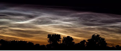
 You can catch a glimpse of noctilucent clouds just after dusk or prior to dawn, when lower layers of atmosphere are still in Earth's shadow, from early June to late July. A Universe Today article provides nice summary of these rare but increasing high altitude (fifty miles up) cloud phenomena. Noctilucent (latin for "night shining") clouds (pictured), are most visible if you reside between 50 degree and 70 degree north of the equator. The 50 degree latitude is just north of US-Canadian border; Britain, Northern Europe and Moscow are also included in the optimum viewing area.
In a 2009 Wired Science article, atmospheric scientist James Russell believes CO2 buildup in the upper reaches, which actually pushes the atmosphere further into space, lowers temperatures. "The prevailing theory and most plausible explanation is that CO2 buildup, at 50 miles above the surface, would cause the temperature decrease,” says Russell. An increased incidence of these clouds is an indication of climate change, according to atmospheric experts. The article adds, at approximately 230 degrees below zero fahrenheit, dust either blown into the upper atmosphere or from outer space provides a place for water vapor to condense and freeze. Mike Hollingshead, a storm chaser, took picture over Blair, NE, some years ago, his website for more pictures, ExtremeInstability.com. Noctilucent clouds are relatively recent strange phenomena!
No comments:
Post a Comment