from boeing.com: As a pilotless F-16 roared into the sky last week at Tyndall Air Force Base, Fla., members of Boeing’s QF-16 team and the U.S. Air Force celebrated.
The flight represented the first unmanned QF-16 Full Scale Aerial Target flight. Put another way, fighter pilots now have an adversary for which to train against that prepares them like never before.
Two U.S. Air Force test pilots in a ground control station at Tydall remotely flew the QF-16, which is a retired F-16 jet modified to be an aerial target. While in the air, the QF-16 mission included a series of simulated maneuvers, reaching supersonic speeds, returning to base and landing, all without a pilot in the cockpit.
“It was a little different to see it without anyone in it, but it was a great flight all the way around,” said U.S. Air Force Lt. Col. Ryan Inman, Commander, 82nd Aerial Targets Squadron. “It’s a replication of current, real world situations and aircraft platforms they can shoot as a target. Now we have a 9G capable, highly sustainable aerial target.”
Prior to the QF-16, the military used a QF-4 aircraft, which was a modification of the F-4 Phantom, a Vietnam-era fighter The modified QF-16 provides pilots a target that performs closer to many jets flying today.
The QF-16s were all retired aircraft. Boeing retrieved them from Davis Monthan Air Force Base in Arizona and restored them for flight.
Next up, live fire testing moves to Holloman Air Force Base, N.M. The military will ultimately use QF-16s for weapons testing and other aerial training. So far, Boeing has modified six F-16s into the QF-16 configuration.
Showing posts with label uav. Show all posts
Wednesday, September 25, 2013
Monday, August 19, 2013
Domestic Drone Industry Booms
from ActivistPost.com: The drone arms race has gone global. But inside the United States, a study by the Association For Unmanned Vehicle Systems International (AUVSI) showed why drone proliferation continues to ramp up at a nearly exponential rate: it has become one of the fastest growing areas of the U.S. economy. A report entitled, "The Economic Impact of Unmanned Aircraft Systems Integration in the United States" is clear in its conclusion that competition for jobs and tax dollars created by drone tech development is likely to provide the impetus to loosen state regulations on drone use. The AUVSI latest projection is that well over 100,00 new jobs will be created in the first years of full integration.
Of course the AUVSI has a vested interest in promoting drone use despite the organization's "non-profit" status. From their About Us page they don't hide their goals and connections:
Related:
US drone pilot demand outstrips supply
Of course the AUVSI has a vested interest in promoting drone use despite the organization's "non-profit" status. From their About Us page they don't hide their goals and connections:
The Association for Unmanned Vehicle Systems International is the world's largest non-profit organization devoted exclusively to advancing the unmanned systems and robotics community. Serving more than 7,500 members from government organizations, industry and academia, AUVSI is committed to fostering, developing, and promoting unmanned systems and robotic technologies. AUVSI members support defense, civil and commercial sectors. (Read full mission statement and their goals for the world HERE)As Russia Today reports below: "More than 7,000 people descended on DC for the 2013 AUVSI conference . . . Alongside were states like Idaho, North Dakota and Arizona, welcoming these flying bots to their airspace with open arms and open coffers."
Related:
US drone pilot demand outstrips supply
Tuesday, May 21, 2013
OK Drone: Vietnam Enters the UAV Market
“After three days of tests, from May 17-19, in Da Lat city and Lac Duong district of Lam Dong province, six vehicles made by the Vietnam Space Technology Institute, under the Vietnam Academy of Science and Technology (VAST), successfully made 37 flights,” Xinhua News reported, citing local media outlets.
The tests reflect an effort by Vietnam to penetrate the UAV market, with many of its neighbors, including China and Japan, beefing up their own UAV forces in recent years.
Earlier this month the Vietnam Academy of Science and Technology (VAST) had announced that it had built five indigenous UAVs, the first of their kind for Vietnam. The first of the drones—AV.UAV.MS1, AV.UAV.S1, AV.UAV.S2, AV.UAV.S3 and AV.UAV.S4— was initially tested in early May. The Vietnamese scientists who built the drones began researching them back in 2008, and the project was picked up by the state in 2011.
Related:
Vietnam to purchase drones from Belarus
According to Vietnamese news media, the drones have a weight of 4 kg to 170 kg and wingspans ranging from 1.2 to 5 meters. The smallest of these “can fly at 70 kph [kilometers per hour] within a radius of 2 km and at a maximum altitude of 200 m,” while the biggest one “can fly at 180 kph, within a radius of 100 km and at an elevation of 3,000 meters. It can continuously fly for 6 hours in both daytime and nighttime.”
The unmanned aircraft are equipped with cameras, spectrometers and other devices and will be “used for [the] supervision of environmental natural resources in difficult direct approach territories; observation, communication and seashore rescue; exploration of natural resources, control of forest fire[s], and to follow the situation of national electricity system and transport,” VAST’s website has said.
It was not the only scientific breakthrough Hanoi achieved this month, with the country also launching its first remote sensing satellite, the VNRED Sat-1. The satellite was built largely with French funds, Xinhua reported at the time of the launch. Vietnam had previously launched two telecommunication satellites, the first in 2008 and another one last year.
The flight range of some of the drones tested this month can be extended using guiding satellites, according to local media reports.
Although the UAVs are ostensibly only for civilian purposes, their tests were monitored by leaders from the Ministry of Public Security and the Ministry of National Defense.
Alongside the domestic effort to build UAVs, Vietnam is looking to purchase them abroad. Last week it was announced that Vietnam would purchase UAVs from Belarus during Prime Minister Nguyen Tan Dung’s visit to that country. Few details were provided about the type of drones involved in the deal.
Friday, May 17, 2013
UAVs are searching for oil in Norway
from stratrisks.com: Like an army, science needs the high ground. This is true when it comes to oil exploration and especially so in the rugged landscape of Norway. The Virtual Outcrop Geology (VOG) group at the Norwegian Centre for integrated petroleum research (CIPR) is working to capture this vantage point in a distinctly 21st century way, by using UAVs to seek out oil by helping geologists build 3D models of the terrain.
We tend to think of oil exploration as taking place on desert plains or out in the ocean, but finding oil deposits depends on having a comprehensive understanding of local geology, which is one reason why the question of how much oil we have left sparks so much argument – there’s still so much we don’t know about most of the Earth. By studying the Norwegian terrain and matching it up with other data, such as that gathered from seismographs and core drilling, geologists can build up a three-dimensional picture of what’s going on beneath the ground – both on land and under the sea.
“A landscape’s surface often reflects what lies beneath ground and corresponds with the rocks below the seabed. When we have an overview of the rocks and minerals in one area, it is far easier to make estimates about where to find oil and how the oil flows,” said Simon Buckley, senior researcher at CIPR and head of the VOG group.
Such surveys can be arduous, time-consuming and expensive, with teams of experts tramping over mountains to take measurements with optical instruments, laser scanners, infrared sensors and digital cameras. Many times, the terrain is too mountainous for the teams to get everywhere, so helicopters have to be hired to fill in the gaps.
The researchers describe the drones as being like a camera tripod in the sky. That may sound trivial, but gaining the ability to survey terrain straight down from a height is a tremendous advantage. The information is much clearer, it’s easier to match images to one another and to correlate with ground images, and it’s easier to build up stereoscopic images from which 3D models can be made. A UAV not only allows geologists to do this more cheaply than with a helicopter, but also at heights and in areas where using a ‘copter would be too dangerous, if not impossible.
Similar to techniques used for mineral surveys in Switzerland and Germany, the helicopter-like UAV used by CIPR carries the scanners, sensors and cameras needed for the survey, and helps geologists to build a more precise 3D model of the area that can be flown over and studied virtually. In this way, they can learn about the types of rock present, the thickness of sediments, and other aspects of geological formations to help in finding oil deposits.
The main restrictions on the drones are regulatory. The ground controllers who operate the UAV and its cameras need to be certified in a simulator by the Norwegian aviation authorities and must exercise extreme care in avoiding populated areas.
CIPR is a joint venture between the University of Bergen (UiB) and Uni Research.
We tend to think of oil exploration as taking place on desert plains or out in the ocean, but finding oil deposits depends on having a comprehensive understanding of local geology, which is one reason why the question of how much oil we have left sparks so much argument – there’s still so much we don’t know about most of the Earth. By studying the Norwegian terrain and matching it up with other data, such as that gathered from seismographs and core drilling, geologists can build up a three-dimensional picture of what’s going on beneath the ground – both on land and under the sea.
“A landscape’s surface often reflects what lies beneath ground and corresponds with the rocks below the seabed. When we have an overview of the rocks and minerals in one area, it is far easier to make estimates about where to find oil and how the oil flows,” said Simon Buckley, senior researcher at CIPR and head of the VOG group.
Such surveys can be arduous, time-consuming and expensive, with teams of experts tramping over mountains to take measurements with optical instruments, laser scanners, infrared sensors and digital cameras. Many times, the terrain is too mountainous for the teams to get everywhere, so helicopters have to be hired to fill in the gaps.
The researchers describe the drones as being like a camera tripod in the sky. That may sound trivial, but gaining the ability to survey terrain straight down from a height is a tremendous advantage. The information is much clearer, it’s easier to match images to one another and to correlate with ground images, and it’s easier to build up stereoscopic images from which 3D models can be made. A UAV not only allows geologists to do this more cheaply than with a helicopter, but also at heights and in areas where using a ‘copter would be too dangerous, if not impossible.
Similar to techniques used for mineral surveys in Switzerland and Germany, the helicopter-like UAV used by CIPR carries the scanners, sensors and cameras needed for the survey, and helps geologists to build a more precise 3D model of the area that can be flown over and studied virtually. In this way, they can learn about the types of rock present, the thickness of sediments, and other aspects of geological formations to help in finding oil deposits.
The main restrictions on the drones are regulatory. The ground controllers who operate the UAV and its cameras need to be certified in a simulator by the Norwegian aviation authorities and must exercise extreme care in avoiding populated areas.
CIPR is a joint venture between the University of Bergen (UiB) and Uni Research.
Saturday, September 15, 2012
Drones fly through privacy law loophole
from ap-perspective.blogspot.com: Australian Privacy Commissioner Timothy Pilgrim has warned it may be impossible to use Australia's privacy laws to prevent someone from being filmed secretly in their own home by a drone.
He says he is confident the Federal Privacy Act would control the actions of government agencies or businesses operating a drone for surveillance. However, Commissioner Pilgrim has told Radio National's Background Briefing program the act does not apply to individuals.
"Perhaps one of your neighbours buys one of these things and starts flying it around your local street," he said. "What I am not sure about is whether we have sufficient laws to cover the activities of those individuals."
"For example the Federal Privacy Act doesn't cover the activities of individuals and so in the context of the use of drones, the Act I administer wouldn't come into play."
Commissioner Pilgrim has called on governments to review their privacy and surveillance legislation to ensure it covers the use of drone technology.
He says there are inconsistencies between state and territory surveillance legislation that might apply to the remote-controlled technology.
Currently in Australia no formal qualifications are required to fly a drone, providing it is being used recreationally. Commercial operators must be certified.
The Kill Chain: Australia's drone war
Drone journalism takes off
In Australia there are just 24 CASA (Civil Aviation Safety Authority) certified operators of UAVs and another 10 currently in the process of making applications and being assessed. Unless given special approval, all remotely piloted aircraft must be flown:
He says he is confident the Federal Privacy Act would control the actions of government agencies or businesses operating a drone for surveillance. However, Commissioner Pilgrim has told Radio National's Background Briefing program the act does not apply to individuals.
"Perhaps one of your neighbours buys one of these things and starts flying it around your local street," he said. "What I am not sure about is whether we have sufficient laws to cover the activities of those individuals."
"For example the Federal Privacy Act doesn't cover the activities of individuals and so in the context of the use of drones, the Act I administer wouldn't come into play."
Commissioner Pilgrim has called on governments to review their privacy and surveillance legislation to ensure it covers the use of drone technology.
He says there are inconsistencies between state and territory surveillance legislation that might apply to the remote-controlled technology.
Currently in Australia no formal qualifications are required to fly a drone, providing it is being used recreationally. Commercial operators must be certified.
Related:
Revealed: U.S. flew spy drone missions from Australia The Kill Chain: Australia's drone war
Drone journalism takes off
In Australia there are just 24 CASA (Civil Aviation Safety Authority) certified operators of UAVs and another 10 currently in the process of making applications and being assessed. Unless given special approval, all remotely piloted aircraft must be flown:
- below 400 feet;
- within line of sight of the operator;
- in clear weather conditions; and
- only above unpopulated areas.
CASA spokesman Peter Gibson says new guidelines will direct drone pilots to their responsibilities under various state and federal laws.
"In the guidance material we're about to publish, for example, there is a section on privacy and we refer operators to the Privacy Act and we say to them, you need to be aware of the implications of your operations on the Privacy Act and the privacy of individuals," Mr Gibson said.
The new guidance material will be released to the aviation industry for comment within weeks, possibly even days, Mr Gibson said.
He says CASA's guidance covers "everything from flying training, operations, maintenance, continuing airworthiness – all the issues that operators and controllers of remotely piloted aircraft need to understand and follow to make sure they are maintaining the safety standards we expect".
CASA is also working on approving a world-first trial proposed by Surf Life Saving Australia that would see drones being deployed on surveillance missions, searching for swimmers in distress.
If the trial is successful, the organisation wants to use drones more widely to patrol remote and secluded beaches. It has tested drones equipped with inflatable life buoys that can be dropped near swimmers who are struggling, as well as drones that can sound a siren if sharks or other dangers are spotted.
Labels:
australia,
drones,
surveillance,
uav
Monday, July 23, 2012
US Air Force Testing Drone Lasers Above North Dakota
from slate.com: It’s fair to say North Dakota has a fraught relationship with drones. First there was the strange and historic arrest of a farmer in the state involving an unmanned aircraft.
Now military-grade Predator drones are set to test “non-eye safe” lasers flying near Devils Lake in specially restricted airspace, prompting complaints from civilian pilots about safety.
Late last month, in a significant but little reported development, the FAA approved (pdf file) the establishment of seven areas of restricted airspace to fly Predators above the North Dakota military base Camp Grafton. This means that the drones have been designated a large section of the sky, where they will engage in Air Force training operations at altitudes of 8,000-14,000 feet.
Though military-grade drones are currently flown in remote parts of the United States for border surveillance and on occasion for law enforcement, the Aircraft Owners and Pilots Association believes the restricted zones in North Dakota set a “disturbing precedent.” Why? Because, according to AOPA, it is the “first ever reserved exclusively for UAS [unmanned automated systems] activity, the start of a ‘slippery slope’ that could lead to similar proposals elsewhere.”
The FAA met with strong opposition from the moment it proposed imposing the restricted zones in November last year. The airspace regulator received 43 comments responding to the plan—and just one was supportive. Twenty of the comments expressed concerns about a “possible collision hazard.” Others were worried about how the lasers could pose a hazard to people on the ground, or that the restrictions could cut off civilian flight routes and increase costs because alternative flight plans would be necessary.
The FAA admits that the restricted areas “could impact civil flight training.” But it says civilian planes can still fly their normal paths, so long as they stay at a different altitude than the drones.
In an alarming article on its website, AOPA alleged that eight days after the changes came in to force, a navigational chart was issued to pilots but contained no information about them. “Pilots could be flying into restricted airspace and know nothing about it,” AOPA’s Heidi Williams warned.
The restricted zones are the latest example of the incremental introduction of drones into national airspace. Earlier this month, in another little-reported development, the U.S. Air Force reported it had tested a Predator in national airspace over Louisiana as part of a disaster simulation exercise, in coordination with the FAA, the FBI, and the Department of Homeland Security.
One of the only existing barriers is the absence of drone “sense and avoid” technology to help detect other planes—which is likely to have played a significant part in a collision with a manned aircraft in Afghanistan last year. The U.S. Army recently announced a new radar system it believes could address this problem, and consequently, as Arstechnica notes, it expects to start flying drones in domestic airspace for training by March, 2014. The deadline the FAA has set for full integration of drones into U.S. airspace is Sept. 30, 2015.
Now military-grade Predator drones are set to test “non-eye safe” lasers flying near Devils Lake in specially restricted airspace, prompting complaints from civilian pilots about safety.
Late last month, in a significant but little reported development, the FAA approved (pdf file) the establishment of seven areas of restricted airspace to fly Predators above the North Dakota military base Camp Grafton. This means that the drones have been designated a large section of the sky, where they will engage in Air Force training operations at altitudes of 8,000-14,000 feet.
Though military-grade drones are currently flown in remote parts of the United States for border surveillance and on occasion for law enforcement, the Aircraft Owners and Pilots Association believes the restricted zones in North Dakota set a “disturbing precedent.” Why? Because, according to AOPA, it is the “first ever reserved exclusively for UAS [unmanned automated systems] activity, the start of a ‘slippery slope’ that could lead to similar proposals elsewhere.”
The FAA met with strong opposition from the moment it proposed imposing the restricted zones in November last year. The airspace regulator received 43 comments responding to the plan—and just one was supportive. Twenty of the comments expressed concerns about a “possible collision hazard.” Others were worried about how the lasers could pose a hazard to people on the ground, or that the restrictions could cut off civilian flight routes and increase costs because alternative flight plans would be necessary.
The FAA admits that the restricted areas “could impact civil flight training.” But it says civilian planes can still fly their normal paths, so long as they stay at a different altitude than the drones.
In an alarming article on its website, AOPA alleged that eight days after the changes came in to force, a navigational chart was issued to pilots but contained no information about them. “Pilots could be flying into restricted airspace and know nothing about it,” AOPA’s Heidi Williams warned.
The restricted zones are the latest example of the incremental introduction of drones into national airspace. Earlier this month, in another little-reported development, the U.S. Air Force reported it had tested a Predator in national airspace over Louisiana as part of a disaster simulation exercise, in coordination with the FAA, the FBI, and the Department of Homeland Security.
One of the only existing barriers is the absence of drone “sense and avoid” technology to help detect other planes—which is likely to have played a significant part in a collision with a manned aircraft in Afghanistan last year. The U.S. Army recently announced a new radar system it believes could address this problem, and consequently, as Arstechnica notes, it expects to start flying drones in domestic airspace for training by March, 2014. The deadline the FAA has set for full integration of drones into U.S. airspace is Sept. 30, 2015.
Labels:
air force,
airborne laser,
drones,
lasers,
north dakota,
uav
Friday, December 9, 2011
iran captures cia drone
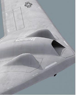
Iran reports capture of CIA drone, this week, on Iran TV. It appears to be a CIA RQ-170 (UAV), taken into possession by Iran about 140 miles inside its eastern border. A New York Times article also reports, "American officials viewing the video declined to confirm or deny that the aircraft shown was the one that they have said was lost several days ago by controllers in neighboring Afghanistan... The loss of an RQ-170 in Iran is a potentially significant intelligence blow for the United States... In an apparent attempt to explain the aircraft’s undamaged appearance, a Revolutionary Guards commander, identified as Brig. Gen. Amir Ali Hajizadeh, said in the video that it 'was brought down by Iran’s military systems with the minimum damage possible'.” Russia and China have asked permission to inspect the captured UAV. Iran attempts to clearly convince the world that this drone capture provides solid proof of America's hostile intentions!
video update: obama appeals to iran to give back downed drone
Subscribe to:
Posts (Atom)